
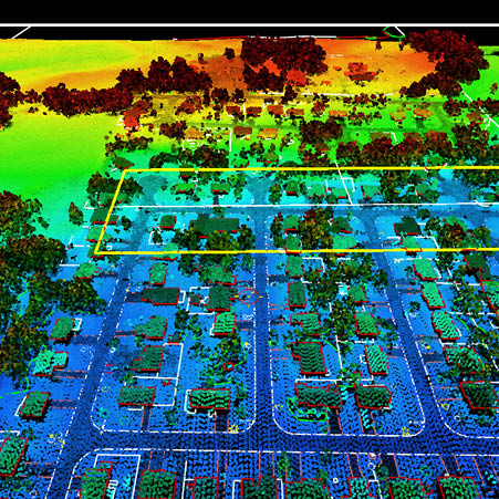
View and edit 3-dimensional point clouds using LandScape from DAT/EM Systems International to provide an advanced and efficient portal into one’s terrain dataset. LandScape is capable of operating on very large terrain point clouds such as from LiDAR or SfM. The operator may choose options to view terrain datasets in stereo within LandScape in standalone mode, or interacting with and superimposed over a Summit Evolution imagery project. LandScape contains a wide variety of automatic and interactive tools to enhance understanding of one’s data by creating, modifying and classifying points as well as drawing vectors based on those points. LandScape’s tools can be configured by the user to further enhance understanding of the data view.
Editing tools in LandScape allow easy modification of point cloud data including a single point, all points in a project or a selection built using LandScape’s filtering tools. LandScape includes the DAT/EM Drawing Tools, a simple built-in vector editor that collects, uses and saves vector features in a variety of formats. For more advanced digitizing tools, additional companion DAT/EM Capture™ modules may be added.
LandScape may optionally integrate with Summit Evolution™ to display the point cloud superimposed over stereo imagery. Use the Summit Evolution cursor to add, select and edit points, and to collect vector data.
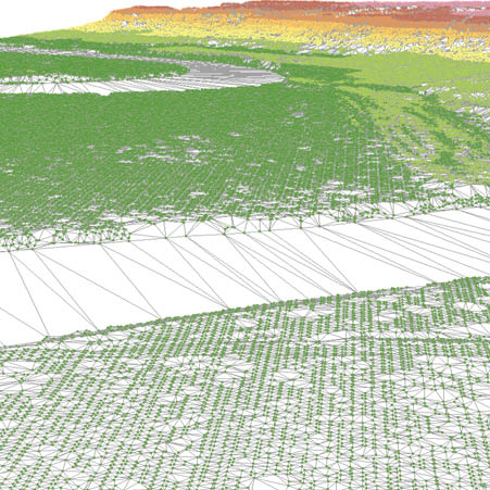
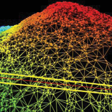
- Profile and perspective stereo view of points. Choice of preferences for coloring and viewing. Roam, zoom, pan and rotate from any angle or distance.
- Point cloud colorization by any attribute contained within the point dataset: elevation, return, flight line, intensity, embedded RGB color, orthophoto RGB color or class.
- No limit to the number of simultaneous input files. The operator has complete control over the amount of detail on display.
- Full 3D mouse and system mouse support for navigation, selection and digitizing.
- Support for mouse button programming and macro creation using DAT/EM Button Manager.
- Automatic point classification filters such as for bare earth, water, roads, buildings, vegetation, railroads, powerlines, color and high/low points. More filters are added with each release.
- Interactive tools: change or add points inside a polygon, filter points around breaklines, shift points onto a plane or surface, save selected points to a separate file and more.
- Brush Z Edit Tool to smooth points inside a brush-size circle using point elevations surrounding the cursor.
- Digitize new 3D vectors such as breaklines with the ability to snap to the surface.
- View existing .dxf, .dwg, .dgn or .shp vector files with the points.
- Draw and edit objects with the built-in vector editor, DAT/EM Drawing Tools.
- Digitize directly into AutoCAD®, MicroStation®, ArcGIS® or Global Mapper® using DAT/EM Capture (optional – sold separately or included with Summit Evolution).
- Use DAT/EM Capture to superimpose existing objects directly from AutoCAD, MicroStation, ArcGIS or Global Mapper.
- Integrate seamlessly with optional Summit Evolution, DAT/EM’s world-class digital photogrammetric workstation. Superimpose LandScape’s points on a Summit stereo model.
LandScape's tools can be used to affect a single point, all points in a project, or a selection built using LandScape’s sophisticated filtering tools. DAT/EM Drawing Tools, a simple built-in vector editor used to collect and save vector features in a variety of formats, is included with LandScape.
Point clouds in LandScape are easily integrated with Summit Evolution and may be viewed in tandem with stereo imagery. Each may be used seamlessly with the other to manage, edit, and collect vector and point cloud data.
For more advanced digitizing tools, one or more companion DAT/EM Capture modules may be added. With Capture, advanced CAD and GIS formats for AutoCAD, MicroStation, ArcGIS and Global Mapper may be superimposed and viewed in the LandScape 3D viewing environment. Objects in those drawings may be used as input into the various tools in LandScape.