
JOIN US AT THE ISPRS EXHIBITION IN PRAGUE
July 2016. Stop by the DAT/EM Booth (#28 & 29) at the ISPRS Prague Exhibition on July 12-16, 2016…

PCI Geomatica
Geomatica from PCI Geomatics is a powerful geospatial image processing software suite used by professionals, researchers and students…

Global Mapper
Global Mapper™ by Blue Marble Geographics® is an affordable and easy-to-use GIS data processing application that offers access to spatial datasets…
Tech Tip: Win10, Summit Status Bar, Image Creator, Poetry
October 2015. While DAT/EM Summit and Landscape may work in Windows 10, there are some serious problems with stereo viewing…

Esri ArcGIS and ArcGIS Pro
Esri® ArcGIS® for Desktop is the key to realizing the advantage of location awareness. Collect and manage data, create professional maps…
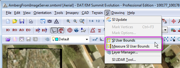
Tech Tip: Summit and CAD/GIS-side SI Clip Settings
September 2015. There may be SI-area-limiting settings offered in both Summit and in the CAD/GIS application…

DAT/EM Expands Technical Support Team
September 2015. DAT/EM Systems International® welcomes Jennifer Dowling to the technical support team…
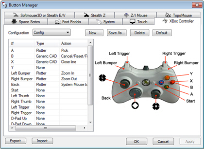
Tech Tip: Sneak Peek of v.7.2
August 2015. DAT/EM will soon release version 7.2. What can you look forward to in the new software…

Tech Tip: Save Yourself a Tale of Woe: UPS and File Saving tips
July 2015. Over the years, DAT/EM Support has heard many tales of woe from customers after they experienced a power outage or power surge…