
3D VECTOR DIGITIZING INTERFACE FOR AUTOCAD, MICROSTATION, ARCGIS, AND GLOBAL MAPPER
DAT/EM Capture is the primary tool for vector information collection from stereo images. Capture works in tandem with DAT/EM’s flagship products, the Summit Evolution™ digital photogrammetric workstation and the LandScape™ point cloud editing toolkit. Capture is included with Summit Evolution Professional, Feature Collection and Lite and is an option for LandScape. Vectors are collected directly into one or more fully-functional companion CAD or GIS programs. Currently supported companion programs are AutoCAD®, MicroStation®, Esri® ArcGIS® and Blue Marble® Global Mapper®. The Capture API (Application Program Interface) is also available to enable development for other companion vector editing programs; third-party Capture versions that were built using the DAT/EM API are available.
Capture works in the background during collection to send 3D (x, y, z) ground coordinates to the companion application. Simultaneously, 2D or 3D features from the CAD or GIS software are rendered back in true relative 3D position in the stereo display using DAT/EM SuperImposition™ for immediate feedback and feature verification. The user’s experience and productivity are enhanced through precise and instantaneous validation of work. The stereo capture capability is also useful to people trying to interpret imagery for their own specialties, such as urban planning, forestry, wetlands biology and geology.
- DAT/EM Capture’s drawing and editing tools make mapping-specific tasks easy to accomplish.
- Custom building squaring modes.
- Choice of 2D and 3D snapping modes.
- Spot elevations.
- A wide selection of multiple-line offsets.
- DTM point collection.
- Adds 3D and stereo tools to the companion application.
- CAD-specific attribute mapping.
- 3D digitizing, vertex dragging, and field editing.
- Vector data superimposition onto stereo imagery in the stereo window.
- Full simultaneous functionality of the companion vector editor.
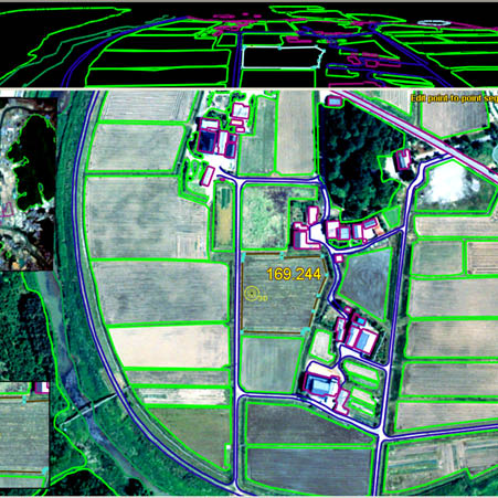
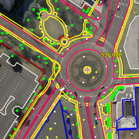
DAT/EM Capture collects 3D image features directly from the DAT/EM Summit Evolution stereoplotter into Esri ArcGIS. DAT/EM Capture provides many 3D data collection and editing enhancements for ArcGIS.
Software features include real-time panning and zooming within a stereo view, 3D digitizing tools such as building squaring, and 3D editing tools such as 3D cut polygon. Snapping may be 3D, 2D or none. Additional tools include multiple field update and ASCII text coordinate file input/output. ArcGIS vectors are superimposed onto the stereo imagery in the Summit Evolution stereoplotter, allowing the user to digitize new objects on the ground and see whether previously existing objects are at the correct elevation.
Airfield3D is a special module included with Summit Evolution Professional Edition and DAT/EM Capture for ArcGIS. Airfield3D builds the surfaces for airfield obstruction analysis according to the specifications in the United States Federal Aviation Administration (FAA) Advisory Circular 150/5300-18B and Part 77 specifications. The obstruction surface outlines are superimposed in the Summit Evolution stereo view, the 3D cursor may be locked to the surface, and a realtime display shows whether the cursor is above or below the surface. Vertically and non-vertically guided runway and custom Part 77 surfaces may be generated. As obstructions are digitized, Airfield3D populates every field that can be determined automatically, plus fields that the user sets such as natural or man-made object designations. Airfield3D can also populate or update fields for previously existing objects, and it offers a tool to create obstruction area grids. Tools to check completeness generate reports and write surfaces to an ArcGIS layer help create the project deliverables.
In addition to digitizing new features, DAT/EM Capture offers the ability to upgrade 2D data to 3D and check coordinate accuracy of existing 3D data. This enables you to easily view, edit, and add to your existing ArcGIS shapefiles and geodatabase feature classes.
DAT/EM Capture together with Summit Evolution Professional Edition can work together to create Summit Evolution projects from stereo raster datasets found in ArcGIS for Server. All other Summit Evolution project types may also be used.
DAT/EM Capture turns the Summit Evolution photogrammetric stereoplotter into a 3D ground coordinate digitizer for AutoCAD®. Image features are collected directly into AutoCAD's DWG format files. DAT/EM Capture provides many digitizing, mapping and editing enhancements for AutoCAD.
DAT/EM Capture includes MapEditor, a 3D data and file editing package. MapEditor reduces overall editing time by performing interactive and batch tasks defined and controlled by the user.
DAT/EM Capture also includes the DAT/EM KeyPad, a 252-button programmable touchpad that can send long command sequences to AutoCAD. Because a single button can make multiple settings and activate a digitizing command, the DAT/EM KeyPad greatly increases the speed and efficiency of the digitizing process.
Capture AutoCAD – Key Features
- Real-time panning and zooming
- Automatic contour labeling routines
- Automatic contour interpolation program
- Automatic join routine for contours between models
- 3D building squaring and automatic stairs generation
- 3D offsets with multiple offset capability
- Enhanced dialog box-driven user interface
- Automatic contour and breakline integrity checks
- Line patterning along 3D polylines and arcs
Included with Capture for AutoCAD
- AutoCAD stereoplotter interface driver
- MapEditor automatic editing routines
- DTM collection capabilities
- Installation and operation manual (electronic)
- Automated installation interface
DAT/EM Capture turns a photogrammetric stereoplotter into a 3D ground coordinate digitizer for MicroStation®. Image features are collected directly into MicroStation's DGN format files. DAT/EM Capture provides many digitizing, mapping, and editing enhancements for MicroStation.
DAT/EM Capture for MicroStation includes MapEditor, a 3D data and file editing package. MapEditor reduces overall editing time by performing interactive and batch tasks defined and controlled by the user.
Capture for MicroStation – Key Features
- Real-time panning and zooming
- Automatic contour labeling routine
- Automatic contour interpolation program
- Automatic join routine for contours between models
- 3D building squaring and automatic stairs generation
- Online editing for multiple-vertex changes
Included with Capture for MicroStation
- MicroStation stereoplotter interface driver
- User commands (MDL’s) for mapping applications
- DTM collection capabilities
- Installation and operation manual (electronic)
DAT/EM Capture™ for Global Mapper connects Global Mapper from Blue Marble Geographics® with any edition of DAT/EM’s famous Summit Evolution stereoplotter. It enables Summit Evolution to be a 3D digitizing device for Global Mapper and allows Global Mapper projects to use the tools of Summit Evolution.
DAT/EM Capture is the interface to collect vector information directly into Global Mapper from stereo images. Capture works in the background to send 3D (x, y, z) ground coordinates to Global Mapper. Simultaneously, 2D or 3D features from Global Mapper are rendered back in true relative 3D position in the stereo display using DAT/EM SuperImpositionTM for immediate feedback and feature verification.
Users of Summit Evolution and Global Mapper can activate the DAT/EM Capture interface in two easy steps. Once connected, the DAT/EM Capture toolbar displays Summit Evolution functions directly from Global Mapper’s home window.
Capture for Global Mapper – Key Features
- Collect and edit 3D data directly into Global Mapper.
- Tools for panning, zooming, and 3D positioning with measurement and terrain following tools.
- Activate Summit Evolution functions from Global Mapper’s home window.
- Display ground-referenced photogrammetric imagery in stereo.
- Track ground coordinates in both Summit Evolution and Global Mapper.
- Use any Summit Evolution edition (Lite, Feature Collection, or Professional) to open the prepared project and start the Global Mapper extension.